Webinar
What is a Webinar I hear you say? Well a webinar is a (sem)inar done on the web, webinar, simple.
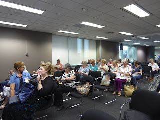
This one was run by the Royal Australian Historical Society (RAHS) and it was on land research- the Parish Map. Carol Liston, Associate Professor, University Western Sydney.
Carol gave a very informative presentation on Parish maps, giving an overview of how they came into being, what to look for on them and how to follow the numbers trail, (those written on the map). She also recommended looking at ALL editions of the map, so you can see the changes that happened. One thing to take note of, is that only the name of the ORIGINAL purchaser is on all of the maps, for other you need the numbers. The only names that changed where Crown land was leased. You need both the Parish and County name to find a map and for that Carole used the Geographical Names Board web site. www.gnb.nsw.gov.au select Search Place Names and follow the instructions. There is a Fact Sheet that is useful.
Once you have the county name, you then switch to web site http://six.nsw.gov.au/wps/portal
this site is where you locate the maps. Go to the little box marked HLRV and that will take you into the correct area. I haven't looked at the site for a while and can't remember if there is a fact sheet. Have a play and see what you find.
Remember that some Parish Names where used more than once, so check that you have the correct County. Make a list of the different ones, if you aren't sure and check them all.
Happy searching,
Lilian
Comments
Post a Comment